

Residential & Commercial
Aerial Images & Mapping
Client Directed
Our flying cameras can capture pretty amazing scenes with ultra high resolution images and a 10bit colour profile.

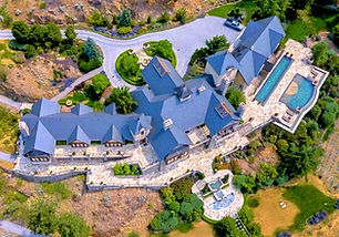
Commercial Real Estate
Capturing the surrounding environment and how the property is situated can only be done from the air. Check out property lines, use for architectural renderings and marketing mockups.
360˚ Panoramic images and video clips for AR/VR walk-throughs bring the project to life. We have a package designed for designers.

Development Projects
Get the lay of land with orthomosaics, 3D models (Digital Twin), Elevation models and contouring. Photogrammetry can assist with measurements and data for site inspection. Share site progress with team members and stakeholders.
Development Project Packages are available for projects of all sizes.
Real Estate & Development
Package Pricing
M
Marketing & Design Team Package
Site photos include:
Client directed
Cardinal Points
POIs
elevations for renderings
Including
1/2 day and full day pricing.
Call for quote.
Video Editing & Photo Enhancing Available
D
Development Project Package
+ POI photos
$849* < 5 acres
Larger properties - ask for quote.
Bi-monthly -15%

Is there a shot or service that you would like added to your package? Just let us know and we'll include it in your quote.
Choose from:
+ client directed shots
+ cardinal points at different altitudes
+ bird's eye (nadir)
+ topographical
+ hyper lapse video (moving time lapse)
+ sunset shots
+ 3D model (Digital Twin)
+ thermal scan
+ creative concepts
+ video editing
+ photo editing
We can also work in collaboration with your terra-photographer and design team to get the images to elevate your project to the next level. We work directly with you to get the images that you have in mind. Ask for a customized quote, as every client has different needs and requirements.
Also included is password accessed private page hosting as a service to our customers to be able to easily access their images to view, download and share for a month. Both .dng(raw) and .jpg files are provided by file transfer.
Our Satisfaction Guarantee - If you're not happy with the results - the follow-up shoot is on us. We are confident you will say "WOW!!" the first time.
360˚ INTERACTIVE PANORAMAS
